The Maryland Department of the Environment (MDE) is responsible for managing the State’s water resources. In 2008, the Advisory Committee on the Management and Protection of the State’s Water Resources reviewed the State’s program and provided recommendations aimed at assisting the State in more effectively meeting its obligations Report. The Committee identified the need for studies in the coastal plain and fractured-rock regions of Maryland, to acquire the comprehensive data necessary to support complex water management and permitting decisions. In response to the Advisory Committee’s recommendations, MDE has initiated comprehensive water supply studies with the assistance of the Maryland Department of Natural Resources Monitoring and Non-Tidal Assessment division (MANTA), the Maryland Geological Survey (MGS), and the United States Geological Survey (USGS).
Funding
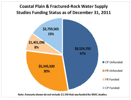
Funding for the water supply studies has come from a variety of sources, including Drinking Water State Revolving Fund Set-Aside funds, State general funds, federal earmarks, and in-kind services from USGS, MGS, MANTA, and MDE. The chart below represents funding through December 31, 2011 by region and depicts funding needed to complete the studies.
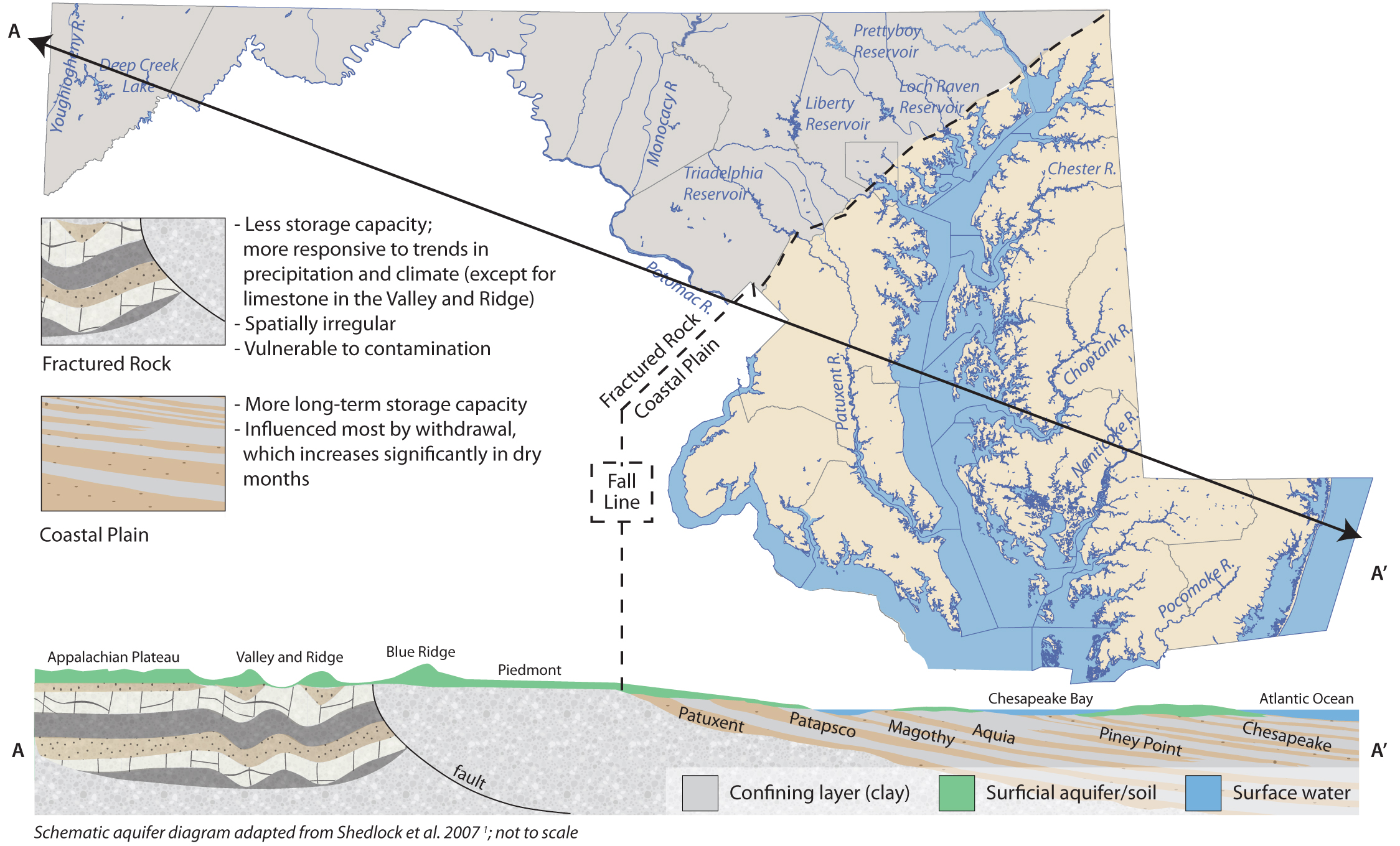
Coastal Plain Regional Study
The coastal plain study was initiated in 2006. To date, a GIS-based computer application, the coastal plain Aquifer Information System (CP-AIS), has been developed and is currently being used by the Water Supply Program permitting staff to evaluate water withdrawal requests. The system maps out the stratigraphy of the coastal plain aquifers using approximately 900 boreholes, 700 aquifer tests, and other data. Some naturally occurring water quality data is included as well. Additionally, the conceptual framework for the region’s groundwater flow model has been developed complete with a regional boundary, data layers, and grid spacing. Eventually this model will be developed and used to evaluate the cumulative impacts of withdrawals, assist with planning, and used to optimize water allocations in the Maryland Coastal Plain.
- A Science Plan for a Comphrensive Regional Assessment of the Atlantic Coastal Plain Aquifer System in Maryland
- Fact Sheet: Sustainability of the Ground-Water Resources in the Atlantic Coastal Plain Of Maryland
- Fact Sheet: Calvert Aquifer System Test Wells Located at Cordova, Talbot County Maryland
- Fact sheet: Calvert Aquifer System Test Wells Located at the Warner Tract, Dorchester County, Maryland
- Fact Sheet: Calvert Aquifer System Test Wells Located at Greensboro, Caroline County, Maryland
- Fact sheet: Monmouth Aquifer System Observation Well Located at Northern Kent County, Maryland
- Fact sheet: Calvert Aquifer System Test Wells Located at Martinak State Park, Caroline County, Maryland
- Fact sheet: Calvert Aquifer System Test Wells Located at Idylwilde Wildlife Management Center near Federalsburg, Caroline County Maryland
- Fact sheet: Aquia Aquifer Test Wells Located Near Church Hill, Queen Anne's County Maryland
- Fact Sheet: Manokin Aquifer Observation Well Located in West-Central Wicomico County Maryland
Fractured-Rock Regional Study
Work on the Fractured-Rock project commenced in 2009. To date, the Fractured-Rock Aquifer Information System (FR-AIS) has been developed for the study’s pilot area. A Science Plan has been drafted outlining the study’s goals and proposed assessment activities and is currently under review. Future work will include identifying factors that affect well yield and evaluating the impacts of withdrawals on aquatic biota.
Crucial Remaining Activities Include
- Development of Maryland Costal Plain Groundwater Model
- Finalization of AIS for the Coastal plain and Fractured Rock regions
- Completion of the coastal plain baseflow separation analysis
- Completion of the StreamStats tool to estimate flows in ungaged watersheds
- Completion of the reliable well yield analysis in the Fractured-Rock region
- Completion of the Fractured-Rock Hydroecological Assessment
- Publication of all scientific reports
- Development of an integrated monitoring network
- Completion of a comprehensive water-use database
- Analysis of research watersheds
- Continuation of outreach activities
For more information
USGS/MDE/DNR/MGS Studies
Contact Information
You can contact the Water Supply program at WATER.SUPPLY@MARYLAND.GOV or at 410-537-3702
